


MEDIEVAL RUINS OF ĒRGĻI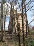
In 1341, Engelbert von Tiesenhausen has begun the construction of a castle, which was completed in 1397. The castle had a rectangular shape. A chapel was situated inside the castle. The round velvet room in the gate tower housed a munitions depot. The castle could be accessed by means of a drawbridge. The castle had 4 towers; the round tower, the quadrangular tower, the long tower and the gate tower. Bathhouses, brick sheds and utility structures were situated in front of the castle. The castle of Ērgļi was destroyed in 1577.
The quadrangular tower with small oblong windows could still be seen about 50 years ago, now all that remains are the ruins.
SKANSTES HILL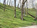
Located in the center of Ērgļi, at the right bank of Ogre river, and is attributed to the fortifications from the late iron age, 9th-12th century. The hill is triangular and 10 meters high. There are records of an impregnable fortress built on the hill. It is known that in 1876 two German priests and the steward of the Ērgļi estate have carried out excavations on the hill. They have found several previously inhabited sites, where the ground contained coal, bones, shards of dishes and stone rubble. The workers digging a channel for the power station in the 1920 have stumbled upon the remains of old structures, hewn wood, which obviously belonged to some bridges across the swamp at the southern foot of the hill settlement.
The hill is an object of cultural and historical importance. In 1998, the banner of the European cultural heritage days was hoisted upon it.
In 1924, the Ērgļi hydropower plant, one of the first in Latvia, has been launched near the hill. After numerous interruptions, the power plant has resumed its operation in 1997. In 2002, the Ērgļi power plant was granted the banner of the European cultural heritage days for preserving and operating Latvia’s industrial heritage.
BLAUMAŅA CEMETERY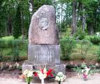
The main entrance to the graveyard is opposite to the tomb where the writer Rudolfs Blaumanis rests, with 45 granite steps leading to the tomb.
The cemetery is divided into four parts :
- the grave of the eminent Latvian writer Rudolfs Blaumanis (1863-1908)is located in the central part of the peasant cemetery. The author of the monument on this tomb is the sculptor Burhards Dzenis. The monument, made from Finnish granite and Braki cobble-stones, has been installed in 1923. These burial grounds house the tombs of native Ērgļi families, including Jurjāni from Meņģeļi, and a number of distinguished people of the Ērgļu district: poet Jānis Grots (1901-1968), teacher Uldis Blaus (1917-1989), artist Ādolfs Lielais (1918-1992), etc.
- the oldest tomb within the Tranzeju section, where landowners of Ērgļi used to be buried, is dated January 1st, 1818, and the most recent one – May 10th, 1881. Seven overlapping plates of the Tranzeju graveyard still remain intact.
- graveyard of the German Lutheran community, where Germans and non-Germans, priests of the community, folk and owners of the estate are buried, is located in the middle section of the cemetery. The oldest grave here is the tomb of Andrejs Kristofs Vīks (1723-1775), a priest of Lutheran communities of Ērgļi and Ogre.
- as to the Orthodox section of the cemetery, no clusters of graves have remained intact here. Ruins of a crypt can be found on an overgrown hillock beneath the trees.
JUMURDAS CASTLE AND PARK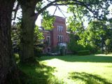
Center of the Jumurdas estate is considered an architectural monument as a whole, being an ancient inhabited site with a very precise functional planning. The status of an architectural monument is given separately to the castle, the park and the pumphouse. An integral element of the landscape within the architectural and building heritage zone is the lake with its opposite shore. The park is situated in a traditional way – between the castle and the lake.
As of today, a very precise structural development planning can still be observed at the former center of the Jumurdas estate, its origins found at the turn of the 18th and 19th centuries.
Jumurdas estate used to be the property of Reinhold Tiesenhausen back in 1523. During the Swedish times, in the 17th century and in the early 18th century, the Tiesenhausens have lost the estate, yet the patrimony was regained by their descendant, Margareta Charlotte von Ermes (born Tiesenhausen), in 1736. The estate was later inherited by her sons. On February 23rd, 1784 it was acquired by the senior of Riga, Adam Henrich von Grote. On April 19th, 1852 Eduard von Tranze has bought the Jumurdas estate for his elder son, Alvil von Tranze. The poet Andrejs Pumpurs has been working as the steward and forest warden of the Jumurdas estate in 1872-1874.
In 1905 the castle was destroyed. From 1906 till 1909 it was owned by a medicine doctor named Reinholds Mihaels Liepiņš. The castle has been restored in 1907.
The last owner of the estate was the forest warden Liberts, who has arrived to Jumurda from Russia and bought a part of the estate from Reinholds Liepiņš.
During the First World War, the Red Latvian Riflemen used to throw parties in the castle. After the war, it was inhabited by the homeless. Later, an oil mill was arranged on the first floor, but since 1929 and for 69 years on the castle was housing the elementary school of Jumurda. As of today, some of the buildings have been renovated and currently house the recreational complex of the Jumurdas estate.
The former center of the Jumurdas estate is located within the protected landscape territory of Vestiena.
V.STRUVE MERIDIAN ARC GEODETIC MEASUREMENT POINT “SESTUKALNS”
Located in Sausnējas parish, Morēnas height (216.5 m above sea level). Morēnas height is nowadays called Ziestu hill.
The Strūve geodetic arc is defined as one of the methods to determine the dimensions and shape of the Earth by measuring the length of the triangulation arc and the astronomic coordinates of the end point of the meridian arc. A geodetic arc is a line pointing in the North – South direction.
The Strūve geodetic arc is a triangulation measurement chain aligned approximately by the 260th meridian from the Hammerfest district in the modern Northern Norway, stretching about 2820 km south to the city of Ismail near the Black Sea. The meridian arc measurement works were conducted from 1816 till 1855, headed by F.G.V.Strūve.
Only two of sixteen Strūves geodetic arc points in Latvia, Sestukalns and Jēkabpils, are included in the World Heritage list and the list of cultural monuments protected by the state.
AKMEŅUPĪTES WATERFALL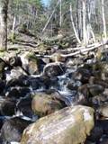
A geological and geomorphologic natural monument developed in 2000.
Akmeņupīte is the right bank influx of Ogre and has a high relative differential – it drops down by some 10 meters along the stretch of just 70 m. The bottom of the river is full of mossy stones with an incredibly rich moss flora. Akmeņupīte used to bear another name of Demon’s windmills – a demon was pulling stones in a bag up the hill in order to build a windmill, but was surprised by a rooster’s cry at midnight and let loose of his bag of stones; now the water from melted snow in spring runs over the stones while going down with a cracking sound, just like windmills make.
RAPIDS OF BRĀŽI.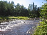
The rapids of Brāži have developed during the time when Ogre river got filled with stones. Steep turns of the river have formed high banks, known as the Red banks due to the layers of clay they reveal. In general, Ogre river valley boasts a great variety of biotopes and species. Research by Latvian Fund for Nature has determined eight biotopes protected by the law in this vicinity. High-speed current stretches of rivers; oak, linden, maple and elm woods in gullies, riverbeds with steep 45-degree turns are a natural wealth protected on the European scale. This is where the especially protected kind of species, ramsons, grows in greater numbers than anywhere else in the Ogre river valley.
A geological and geomorphologic natural monument has been arranged in 2000.
VECOGRES HYDROPOWER PLANT
Address: „Emmas dzirnavas”, Sausnējas parish, Ērgļu district, LV-4841
Phone No. (+371) 4871103, mob. phone No. (+371) 26271556
As of today, this is the Vecogres power plant, yet historically the first mentions of “Emmas dzirnavas” date back to 1730 and regard the mill of the „Ozolmuiža” estate. In early 19th century, the mill, in a totally worn condition, was inherited by the Erhard family. The mill was renovated, and up to the beginning of World War Two it housed several industrial facilities at once: a powersaw bench, a wool-processing plant and a grain mill with all the grinders. At the beginning of the war, the mill was partially destroyed. It has resumed its operation in the German times.
After the war, the mill got de-nationalized and adopted by the wool processing factory of the Ērgļi industrial complex. In 1958, the buildings of the mill were transferred to the authority of Latvenergo, and then there were 2 turbines operating in a separate building, but the former mill building was used as a recreational base. In the 60s, when small hydropower plants were getting closed, Emmas dzirnavas also halted energy production and remained operating solely as a recreational base.
In the 90s, having regained their property, the Erhard family has renovated the small hydropower plant and two turbines were launched in 1996. Another turbine has come online in 2004.
As of today, along with the transfer of ownership, the log dam is replaced with metal construction; lamps are installed in order to enable the facility to operate at nighttime. The turbines work depending on the water flow in the Ogre river ….
IMP’S ARMFUL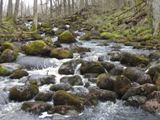
This section of the Nāružiņas river, about a kilometer long, is strewed with large rocks. In summertime, water flows beneath the rocks, but in springtime white foam marks their tops. A tale tells us that once upon a time some fisherman has arranged a millpond on the river and placed his nets. Then he kindled a fire and started baking the fish. An Imp came by and demanded some. The fisherman refused. The imp got mad and said: “then I’ll block the river with rocks, so that all the water would go back to the swamp”. Before the fisherman could object, rocks started falling. The rocks are black in color, which makes specialists suggest that the waters if the river contain a lot of manganese.
The vicinity boasts a number of interesting natural formations, plants are seldom seen. Not far from there is a bizarre excrescence on a birch tree (perhaps this is the imp’s eye?), and one may occasionally stumble upon some lichen on the oak trees further away.
PALŠU SWAMP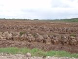
The natural reserve was founded in 1996. The swamp was partially dried, milling peat is mined here. The botanical composition of the swamp is different from the other swamps in the Eastern part of Latvia. This particular swamp houses an especially protected plant – brown bog-rush, which is commonly found in the Piejūras lowland. Water cavities are of a great value for the biological diversity, thanks to their importance for invertebrates and birds.
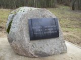
MEMORIAL PLACES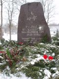
The memorial stone of the politically repressed inhabitants of the district, 1940.-1988.
The memorial of the green partisans fallen on May 23rd, 1919.
The memorial of the Burtnieku school.
The Gaiļakalnāemiņas place on the Gaiļkalns hill – the memorial of the Ērgļi historical, cultural and educational center.
The memorial of the fallen soldiers.
The memorial stone of the politically repressed inhabitants of Liepkalni and Sausnēja, 1942.-1956.
Tomb of the writer Ilze Kalnāre in the Vējavas cemetery.